


Author: Bridge Michigan
Significant Restoration Milestones reached in Buffalo Outer Harbor Slip #3

Significant Restoration Milestones reached in Buffalo Outer Harbor Slip #3
josterme01
Fri, 08/30/2024 – 3:15 pm
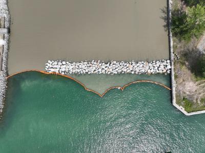
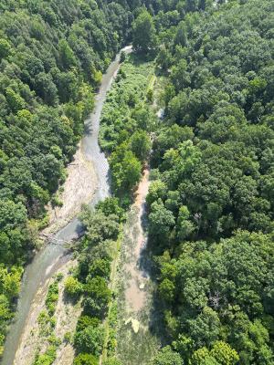
An aerial image shows turbidity curtains placed adjacent to the breakwater at the end of Buffalo Outer Harbor Slip #3. (Credit: USACE Buffalo District)
The US Army Corps of Engineers (USACE), Buffalo District, in partnership with the U.S. Environmental Protection Agency, has achieved a significant milestone by beginning construction of a habitat restoration project in the Niagara River Area of Concern (AOC) intended to restore coastal wetlands through the use of clean sediment dredged in Buffalo, NY. USACE is conducting this $14 million+ restoration project in partnership with the Erie Canal Harbor Development Corporation, with partial funding from the Great Lakes Restoration Initiative and support from a diverse group of regional stakeholders. The project was identified as an important management action by the New York State Department of Environmental Conservation and other AOC partners to address the Fish and Wildlife Habitat Beneficial Use Impairment for the Niagara River AOC.
The restoration project will use the clean sediment that was dredged as part of USACE Buffalo District’s mission to sustain safe commercial navigation on the Great Lakes. USACE Buffalo District began the Outer Harbor Slip #3’s aquatic habitat features by partially enclosing a former shipping slip with stones.
Now, the USACE Buffalo District has begun placing the clean sediment that was dredged into the slip to restore 6.7 acres of coastal wetland habitat. The new habitat will provide improved conditions for submerged and emergent vegetation types that are important to native fish and birds. Clean sediment that was dredged will be placed into the slip over three biannual cycles, concluding in 2028. After the final placement cycle, USACE will shape the sediment and provide additional final habitat features, including rock piles, tree root wads, and gravel beds.
The Outer Harbor Slip #3 restoration project is significant on multiple levels because it is a testament to the effectiveness of historic work to remediate legacy contamination in the Buffalo River through the Great Lakes Legacy Act and the success of Buffalo District’s Strategic Navigation mission. For example, the sediment used to restore this vital coastal wetland habitat was thoroughly tested and determined to be clean and suitable for placement in the outer harbor – a direct result of previous sediment remediation efforts in the AOC. Additionally, the project represents innovation in how the Army Corps manages dredged sediment as a valuable resource which can be used to benefit the public. Finally, the project is an important step in efforts to de-list the Niagara River as an AOC by creating coastal wetlands that are critical nursery habitat for native fish species and have been severely depleted in the Niagara River.
Fri, 08/30/2024 – 3:15 pm
Forest Service Grant Supports Invasive Species Control In the Saginaw Bay Watershed

Forest Service Grant Supports Invasive Species Control In the Saginaw Bay Watershed
josterme01
Wed, 08/28/2024 – 11:14 am
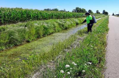
Saginaw Bay CISMA’s strike team member Jami VanScoyoc conducts European frog-bit treatment in July 2024 along a roadside ditch of Sagatoo Road in Arenac County, which leads to the Saginaw Bay. Invasive European frog-bit can spread through roadside ditches, drains and canals further inland or into the bay. Courtesy photo by Stephanie Hoyle, Saginaw Bay CISMA.
The USDA Forest Service provided $50,000 to the Saginaw Bay Cooperative Invasive Species Management Area (CISMA) to establish a two-person strike team to monitor and prioritize invasive plant species including phragmites and Japanese knotweed. The Saginaw Bay watershed is the largest in Michigan and Saginaw Bay itself hosts a critically important and expansive Great Lakes coastal wetland system. The Saginaw Bay CISMA established a two-person strike team to monitor and prioritize invasive plant species.
During the last two years, the strike team monitored over 700 acres for invasive plants and treated over 250 acres to control phragmites, Japanese knotweed, and European frog-bit population and spread. Two shoreline sites, one just south of Au Gres and another just north of Sebewaing, along with roadsides and a few private parcels were treated for phragmites primarily during 2023 using the grant funding. Japanese knotweed treatments were also conducted in multiple locations. Invasive plants were either sprayed with herbicide on the ground or water, or pulled from the water during the treatments.
Saginaw Bay CISMA and the Michigan Department of Transportation coordinated and shared their data to treat Japanese knotweed on public highways and private parcels. Working with the Arenac County Road Commission, Saginaw Bay CISMA also placed signs about the CISMA’s treatments for phragmites throughout the roadside treatment area in the county, particularly in areas that had long stretches of phragmites.
Wed, 08/28/2024 – 11:14 am
Utilizing Abandoned Canal Infrastructure to Create Innovative Water Quality Solutions in the Finger Lakes, NY

Utilizing Abandoned Canal Infrastructure to Create Innovative Water Quality Solutions in the Finger Lakes, NY
josterme01
Tue, 08/27/2024 – 12:41 pm
Main channel of the Keuka Outlet (left) and the Crooked Lake Canal basin (right) after a 40-year storm event on August 09, 2024 that overtopped the trail. This project will help direct excess water from the stream flows into the canal during large storm events. Photo Credit: Seneca Lake Pure Waters Association
GLRI funds are supporting an innovative approach to water quality improvement in the Finger Lakes region of New York State. Efforts are underway to reestablish surface water conductivity of the abandoned Crooked Lake Canal that runs parallel along the Keuka Outlet stream to create wetland habitats in sections of the unused, historic canal system. Keuka Outlet begins in Penn Yan as the outflow of Keuka Lake, extending about 8 miles and dropping 270 feet in elevation to ultimately empty into Seneca Lake at Dresden, NY. The Seneca Watershed Intermunicipal Organization (SWIO), Seneca Lake Pure Waters Association and Finger Lakes Institute of Hobart and William Smith College have long documented excessive nutrient pollution, streambank erosion and downstream flooding along the Keuka Outlet, impacting Seneca Lake downstream. Fortunately, remnants of the historic canal system provide a solution to these water quality issues.
Four locations along the Canal/Outlet channels have been identified as viable diversion locations for this project. Two diversion locations involve the installation of pre-cast concrete pond risers within tributaries flowing from the north into the Keuka Outlet. This management technology maintains normal flows under normal conditions. However, when flow rates increase, water begins to collect and eventually flows downhill into areas of the former canal when the flow of water increases. At two other diversion locations, water will be directed out of the Keuka Outlet via culverts. These culverts are set an elevation such that water only flows into them under stormflow conditions when water quality is at its worst.Model estimates suggest the combined systems can divert 34 million gallons of stormwater flows and sequester 45 pounds of phosphorus from a single 10-year storm event. Project partners are leveraging the ecosystem services of the former canal system/newly reconnected wetland areas to mitigate flooding, reduce streambank erosion and reduce excessive phosphorus transport in downstream Seneca Lake.
The project leverages the Keuka Outlet Trail and partnership with the Friends of the Outlet – an organization dedicated to preserving the history, environmental benefits and recreation access along the Outlet and to maximize public engagement. This past spring, SWIO and Keuka College Visual Communication Design students conceptualized and created interpretive signage for each of the four diversion locations highlighting the unique history and water quality solutions of the former Crooked Lake Canal. This project is an example of innovative repurposing of an abandoned canal system to yield much needed environmental benefits for the Great Lakes Basin.
Tue, 08/27/2024 – 12:41 pm
GLANSIS Identifies Top 10 Most Harmful Great Lakes Invaders

GLANSIS Identifies Top 10 Most Harmful Great Lakes Invaders
josterme01
Mon, 08/26/2024 – 11:23 am
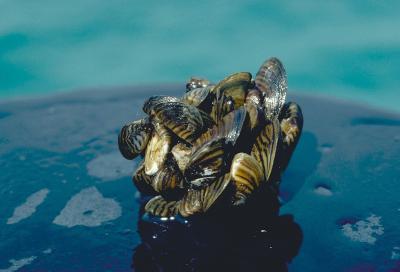
Zebra mussels, as seen here, were ranked as having the most negative impact on the Great Lakes
The Great Lakes Aquatic Nonindigenous Species Information System (GLANSIS) team characterized the impacts of the top 10 Great Lakes aquatic invasive species. Based on the analysis, 78 of the 188 species listed in the database were scored as invasive. Of these 78 species, 32 species had moderate impacts and 36 species had high impacts. The remaining 10 species had exceptionally strong impacts in multiple categories.
Which invasive species have the most significant negative impacts in the Great Lakes? Based on GLANSIS impact scores, they include: zebra mussels, quagga mussels, alewife, sea lamprey, Japanese stiltgrass, grass carp, water chestnut, phragmites, round goby, and white perch.
These species come from different continents and from different pathways of introduction (such as through ballast water, shipping channels, or the aquarium trade). Their most common shared impacts are threats to and competition with native species, altering predator/prey dynamics, and costly damage to human recreation and enjoyment of natural areas, along with harming economic activities. These rankings can serve as a reference point for researchers, educators and science communicators throughout the Great Lakes region. Read the paper here.
Mon, 08/26/2024 – 11:23 am
NOAA Announces Indigenous Communities Awards Under the Great Lakes Bay Watershed Education and Training (B-WET) Program
 Program")
NOAA Announces Indigenous Communities Awards Under the Great Lakes Bay Watershed Education and Training (B-WET) Program
josterme01
Tue, 08/20/2024 – 1:47 pm
Students from the 2022 Learning from the Land Summer Youth Program explore rocks and water while learning about local geology at Bad River Falls. Photo credit: Red Cliff Band Education Department.
The National Oceanic and Atmospheric Administration has awarded $255,973 in funding for three projects that will engage Indigenous youth in meaningful place-based watershed educational experiences through the Great Lakes Bay Watershed Education and Training (B-WET) program. This initiative is supported by the Great Lakes Restoration Initiative under Focus Area 5: Foundation for Future Restoration Actions.
Funded projects:
- Michigan Technological University, partnering with Keweenaw Bay Indian Community: Increased Water Literacy & Stewardship with the Keweenaw Bay Indian Community: Water is Life
- Seneca Nation of Indians: Seneca Nation B-WET project
- Tip of the Mitt Watershed Council, partnering with Little Traverse Bay Bands of Odawa Indians: Nimiigwechwendam Nibiish (I am thankful for water): Caring for our local watersheds
NOAA B-WET is an environmental education program that promotes place-based experiential learning for K-12 students and related professional development for teachers. B-WET fosters the growth of new, innovative programs and encourages capacity-building and environmental education partnerships. The primary delivery of B-WET is through competitive grants that promote Meaningful Watershed Educational Experiences (MWEEs). The MWEE is a learner-centered framework that focuses on investigations into local environmental issues and leads to informed stewardship action.
Tue, 08/20/2024 – 1:47 pm